Software Suite
Last Updated: January 2020
The Tethys Software Suite is a collection of recommended software that can be used with Tethys Platform. The primary motivation of creating the Tethys Software Suite was overcome the hurdle associated with selecting a GIS software stack to support spatial capabilities in apps.
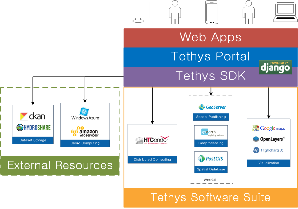
A majority of the software projects included in the Tethys Software Suite are web GIS projects that can be used to acquire, modify, store, visualize, and analyze spatial data, but it also includes other software to address computing and plotting needs of spatial web apps.
Spatial Database Storage

Tethys Platform includes support for multiple spatially enabled databases for Tethys web apps.
PostgreSQL with PostGIS: Provides full spatial data storage and analysis capabilities. PostGIS adds spatial column types including raster, geometry, and geography, along with database functions for GIS analysis.
SQLite with SpatiaLite: Offers a lightweight spatial database option. SpatiaLite extends SQLite with support for spatial data types and functions, allowing apps to store and manipulate GIS data without requiring a full database server.
To use a PostgreSQL or SQLite database in your app use the Persistent Stores API. To use a spatially enabled database with PostGIS or SpatiaLite use the Spatial Persistent Stores API.
Map Publishing

Tethys Platform provides support for GeoServer as one option for publishing spatial data as web services. GeoServer is used to publish common spatial files such as Shapefiles and GeoTIFFs in web-friendly formats.
To use the map publishing capabilities of GeoServer in your app refer to the GeoServer Docker documentation and use the Spatial Dataset Services API.
THREDDS Data Server
Tethys Platform supports the THREDDS Data Server as an alternative option for publishing spatial data as web services. "The THREDDS Data Server (TDS) is a web server that provides metadata and data access for scientific datasets, using OPeNDAP, OGC WMS and WCS, HTTP, and other remote data access protocols. The TDS is developed and supported by Unidata, a division of the University Corporation for Atmospheric Research, and is sponsored by the National Science Foundation."
To use the map publishing capabilities of the THREDDS Data Server in your app refer to THREDDS Docker documentation and use the Spatial Dataset Services API.
Geoprocessing
52°North Web Processing Service (WPS) is supported in Tethys Platform as one means for supporting geoprocessing needs in geoscientific web app development. It can be linked with geoprocessing libraries such as GRASS, Sextante, and ArcGIS® Server for out-of-the-box geoprocessing capabilities.
The PostGIS extension, included in the software suite, can also provide geoprocessing capabilities on data that is stored in a spatially-enabled database. PostGIS includes SQL geoprocessing functions for splicing, dicing, morphing, reclassifying, and collecting/unioning raster and vector types. It also includes functions for vectorizing rasters, clipping rasters with vectors, and running stats on rasters by geometric region.
To use 52°North WPS or other WPS geoprocessing services in your app use the Web Processing Services API.
Visualization

OpenLayers is a JavaScript web-mapping client library for rendering interactive maps on a web page. It is capable of displaying 2D maps of OGC web services and a myriad of other spatial formats and sources including GeoJSON, KML, GML, TopoJSON, ArcGIS REST, and XYZ.
To use an OpenLayers map in your app use the Map View Gizmo of the Template Gizmos API.

Cesium JS™ is an open-source Javascript library for creating world-class 3D globes and maps with the best possible performance, precision, visual quality and ease of use.
To use a Cesium map in your app use the Cesium Map View Gizmo of the Template Gizmos API.
Plotting capabilities are provided by Highcharts, a JavaScript library created by Highsoft AS. The plots created using Highcharts are interactive with hovering effects, pan and zoom capabilities, and the ability to export the plots as images.
To use an Highcharts in your app use the Plot View Gizmo of the Template Gizmos API.
The Plotly Python Library makes interactive, publication-quality graphs. Examples of how to make line plots, scatter plots, area charts, bar charts, error bars, box plots, histograms, heatmaps, subplots, multiple-axes, polar charts, and bubble charts. Plotly.py is free and open source and you can view the source, report issues or contribute on GitHub.
To use an Plotly in your app use the Plotly View Gizmo of the Template Gizmos API.
Distributed Computing

To facilitate the large-scale computing that is often required by geoscientific applications, Tethys Platform leverages the computing management middleware HTCondor and Dask Distributed.
To use the HTCondor or Dask and the computing capabilities in your app use the Jobs API.
File Dataset Storage
Tethys Platform does not include software for handling flat file storage. However, Tethys SDK provides APIs for working with CKAN and HydroShare to address flat file storage needs. Descriptions of CKAN and HydroShare are provided here for convenience.
CKAN is an open source data sharing platform that streamlines publishing, sharing, finding, and using data. There is no central CKAN hub or portal, rather data publishers setup their own instance of CKAN to host the data for their organization.

HydroShare is an online hydrologic model and data sharing portal being developed by CUAHSI. It builds on the sharing capabilities of CUAHSI’s Hydrologic Information System by adding support for sharing models and using social media functionality.
To use a CKAN instance for flat file storage in your app use the Dataset Services API. HydroShare is not fully supported at this time, but when it is you will use the Dataset Services API to access HydroShare resources.
WebSocket Communication
Tethys Platform supports WebSocket connections using Django Channels. Django Channels is an official Django project that brings asynchronous and long-running connections to the synchronous Django.
The WebSocket protocol provides a persistent connection between the client and the server. In contrast to the traditional HTTP protocol, the webscoket protocol allows for bidirectional communication between the client and the server (i.e. the server can trigger a response without the client sending a request). Django Channels uses Consumers to structure code and handle client/server communication in a similar way Controllers are used with the HTTP protocol. When creating a WebSocket connection, a "handshake" needs to be established between the client and server.
For more information about Django Channels and Consumers visit the Django Channels docummentation.
For more information on establishing a WebSocket connection see the JavaScript WebSocket API. Alternatively, other existing JavaScript or Python WebSocket clients can we used.
To create a URL mapping using the WebSocket protocol see the example provided in the App Base Class API documentation.
Docker Installation
Tethys Platform uses Docker virtual container system as an optional component to simplify the installation of some elements. Docker images are created and used to create containers, which are essentially stripped down virtual machines running only the software included in the image. Unlike virtual machines, the Docker containers do not partition the resources of your computer (processors, RAM, storage), but instead run as processes with full access to the resources of the computer.
Four Docker images are supported as part of Tethys Platform including:
PostgreSQL with PostGIS
52° North WPS
GeoServer
THREDDS
The installation procedure for each software has been encapsulated in a Docker image reducing the installation procedure to three simple steps:
Install Docker
Download the Docker images
Deploy the Docker images as containers
SDK Relationships
Tethys Platform provides a software development kit (SDK) that provides application programming interfaces (APIs) for interacting with each of the software included in the Software Suite. The appropriate APIs are referenced in each section above, but a summary table of the relationship between the Software Suite and the SDK is provided as a reference.
Software |
API |
Functionality |
|---|---|---|
PostgreSQL, SQLite |
SQL Database Storage |
|
PostGIS, SpatiaLite |
Spatial Database Storage and Geoprocessing |
|
GeoServer |
Spatial File Publishing |
|
THREDDS Data Server |
Spatial File Publishing |
|
52° North WPS |
Geoprocessing Services |
|
OpenLayers, Google Maps, HighCharts |
Spatial and Tabular Visualization |
|
HTCondor, Dask |
||
CKAN, HydroShare |
Flat File Storage |